Last updated on 29 July 2020
When it comes to lakes, Rila has a lot to offer as there are nearly 200 glacial lakes in the mountain range. Let’s take a look at some of the most exciting ones.
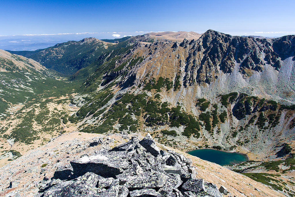
The Seven Rila Lakes
The Seven Rila Lakes (BG: Седемте рилски езера, Sedemte rilski ezera) are the most visited group of lakes and among the most visited natural wonders of Bulgaria. The lakes are situated between 2095 and 2535 m above sea level, gradually one above the other, connected by small streams. These outflows form several little waterfalls.
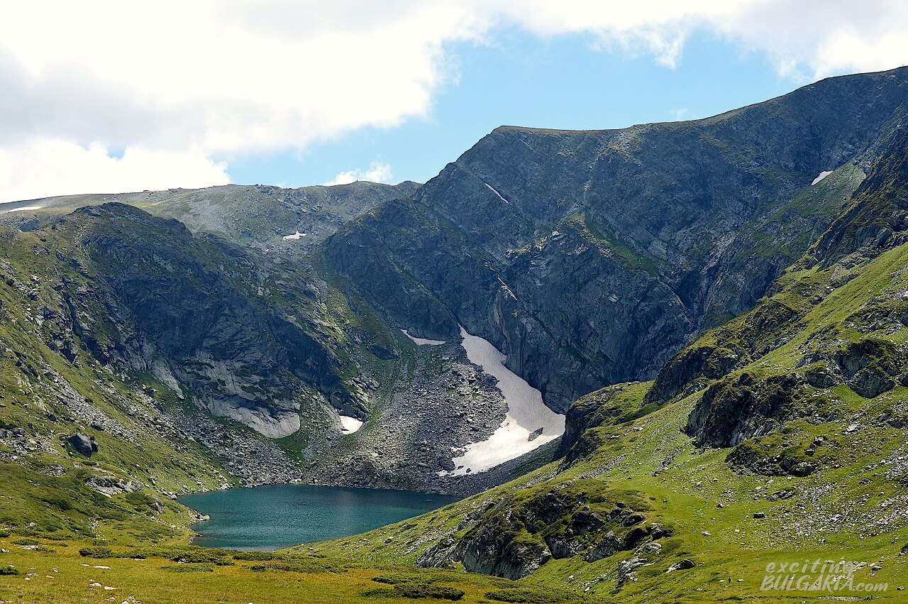
The lakes are all named after their main characteristics. The most spectacular one is probably “The Kidney” with its steep shores and the high peaks in the background. It is recommended to visit the lakes in July or August when the temperatures are the highest, and sudden storms are less likely. The lakes are usually frozen between October and June.

How to get to the Seven Rila Lakes
The lakes are located in the northwestern part of Rila, about 90 km from Sofia and 20 km from Sapareva Banya. The best way of reaching the lakes is going up by the chairlift located next to road 6206 (GPS: 42.23995, 23.32686). Just follow road 6206 from Sapareva Banya and look for the signs. Paid parking is provided near the lower station for 5 BGN per day. The cost of a return ticket to the chairlift is 20 BGN, the ride takes about 25 minutes one way. Try to avoid visiting the lakes on summer weekends as there can be very long queues at the lift.
GPS coordinates: N 42.205014, E 23.310265
The Musala Lakes
The Musala Lakes (BG: Мусаленски езера, Musalenski ezera) are a group of seven lakes in the eastern part of Rila, east to Aleko peak (2717 m) and north to Musala peak (2925 m), the highest in Bulgaria and the Balkans. The lakes are the source of the Bistritsa river, a tributary of the Iskar.

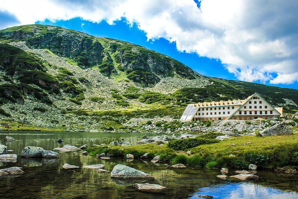
The southernmost lake, called Icy lake (Леденото езеро, Ledenoto ezero) is the highest one on the Balkan peninsula with an altitude of 2709 m. It is also the deepest in the group (16.4 m depth). The largest lake is the fifth from south to north, called Karakash (Каракашевото езеро), with an area of 10.6 ha. The lowest lake is the northernmost one at an altitude of 2389 m. There is a chalet called Musala hut by its northern shore.
How to get to the Musala Lakes
The Musala Lakes have a tourist-friendly location with amazing views of Musala. You can easily reach them by taking the Yastrebetz cabin lift, starting from the center of Borovets. It will take you from an altitude of 1315 m up to 2369 m in about 25 minutes. The working hours are from 08:30 to 18:30.The last ride uphill starts at 17:30 and at 18:00 back down to Borovets. The return ticket for adults costs 12 BGN. Please note that the lift is closed on Mondays and Tuesdays. There is a chalet and restaurants at the upper station. From there, it’s a 4 km convenient hike following the red marked trail. The upper station of the lift is at about the same altitude as the closest and lowest lake, so you don’t need to walk uphill too much.
GPS coordinates (Musala hut): N 42.197890, E 23.587503
Smradlivo (‘Stinking’ or ‘Smelly’) Lake
The Smradlivo Lake (BG: Смрадливо езеро), located in the central part of Rila, is the largest glacial lake of Bulgaria and the Balkan peninsula. It is situated at an altitude of 2298 m in a hanging valley between peaks Kyoravitsa (2612 m) to the southeast and Rilets (2713 m) to the southwest.
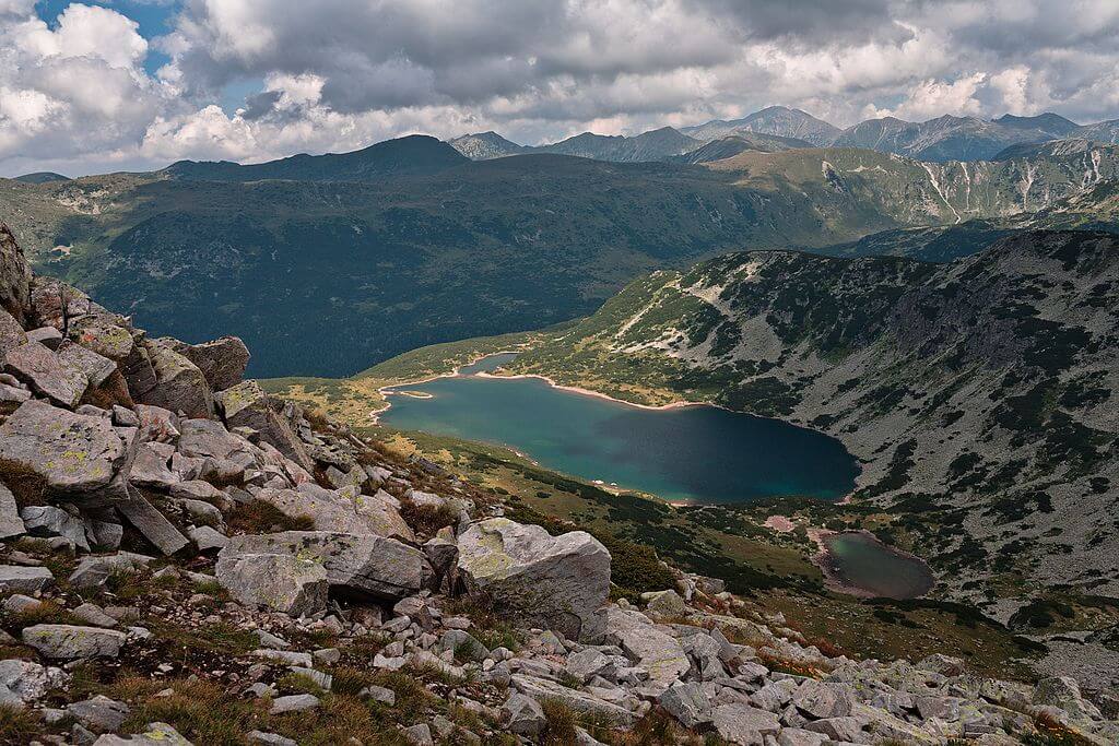
The area of the lake is about 21 ha, with a maximum length of 900 m, width of 260 m and depth reaching 24 m. It is one of the 5 lakes in the group Smradlivi lakes. Its outflow in the north, which is regulated by a dyke, forms a stream leading into the Rilska river, a tributary of the Struma river.
The name of the lake is associated with the legend that once the fish was thrown out of the lake by a huge storm, causing them to smell on the shore. But don’t worry, the lake is not stinking at all. Indeed, it has crystal clear water, ideal for the brown trout population living in it. It is quite a remote lake, chamois, red deer or even brown bears can appear in the area.
How to get to Smradlivo Lake
The lake is reachable from the beautiful meadow called Kirilova polyana which has stunning views of the nearby peaks. You can get there by car on road No. 107, passing the Rila Monastery.
From there, you can follow the dirt road with yellow markings. There is a junction at the end of the dirt road at a mountain house called Tiha Rila (Кантон Тиха Рила). The steeper but shorter trail to the right will take you to Smradlivo lake directly. If you continue straight at the house, you will reach the Fish lakes (Рибни езера) first. You can get to Smradlivo lake by continuing to follow the yellow marked trail from the Fish lakes hut.
Both trails from the shelter are yellow marked as they form a circle between the house and the lakes. The hike is about 9 km long and has an elevation gain of 800 m. Please note that driving up to the shelter house is possible but not recommended for vehicles without off-road capabilities.
GPS coordinates: N 42.121214, E 23.474321
The Fish Lakes
The Fish Lakes (BG: Рибните езера, Ribnite ezera) are a group of 2 larger and several small intermittent lakes in the central part of Rila. They are located between the summits Kyoravitsa (2612 m) to the west, Kanarata (2667 m) to the south and Yosifitsa (2697 m) to the northeast.

The upper lake, situated at an altitude of 2226 m, is the bigger one measuring around 800 m x 300 m. Its northern part is a concrete overflow. The lower lake is about half the size but both have a maximum depth of 9 m. The stream coming from the lakes flows into the Rilska river, a tributary of the Struma. There is a hut between the two lakes (хижа Рибни езера).
How to get to the Fish Lakes
You can access the lakes from Kirilova polyana as described in the section about Smradlivo lake. Follow the yellow marked trail straight from the Tiha Rila house until you reach them.
GPS coordinates (Lower lake): N 42.117171, E 23.495286
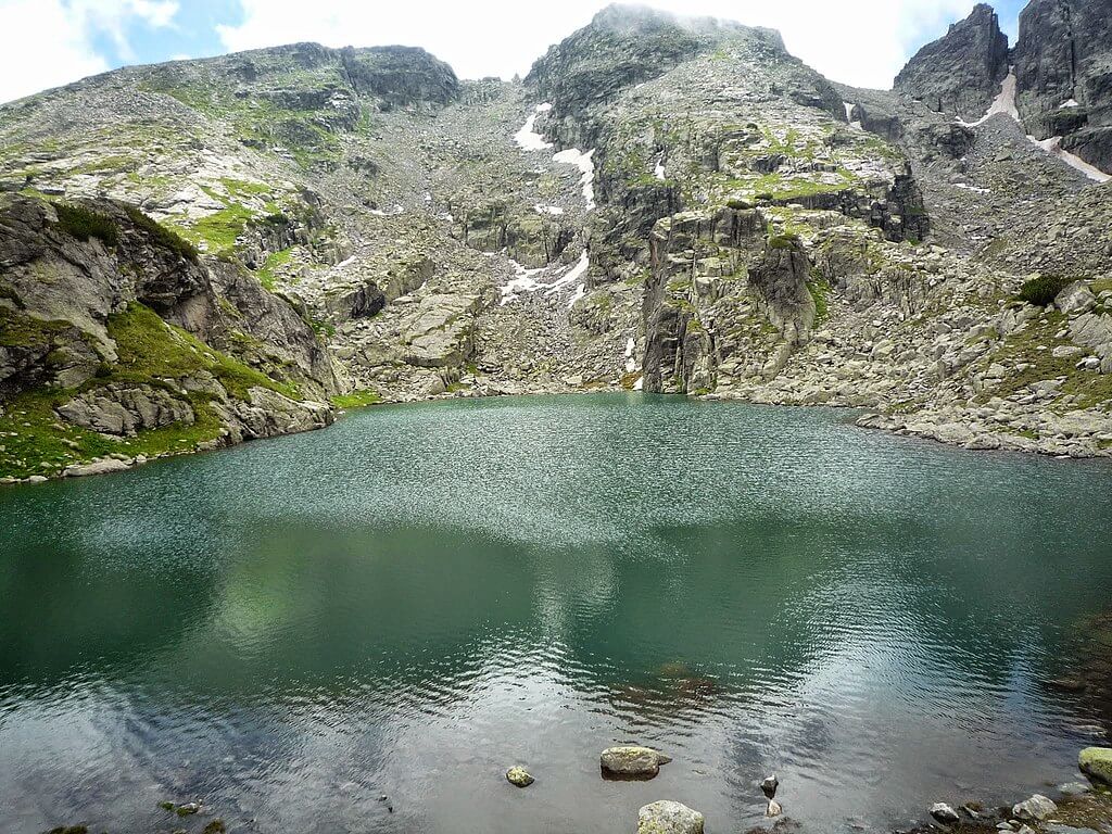
Scary Lake
Scary Lake (BG: Страшното езеро, Strashnoto ezero) is a lake located in the northwestern part of Rila at an altitude of 2465 m, north to Popova Kapa and Kupen peaks (2731 m). It is the largest (about 200 m x 75) and highest in the group of lakes in this cirque.
The name comes from painter Hristo Yonchev, who unintentionally named it after he escaped from a heavy thunderstorm by the lake. When he was asked what happened, he could only reply “Scary, the lake, scary”. Yonchevo lake, located lower to the north was named after him.
How to get to Scary Lake
There are two main trails that you can choose from, both start from the car park of Malyovitsa Central Mountaineering School. One is through Malyovitsa hut, you need to take the blue marked trail to get there. From the hut, following the red and yellow marks will lead you to the lake. The other trail follows the green mark from the car park, passing Yonchevo lake, then following the blue mark from there to reach Scary Lake. The latter is a rather difficult hike with some boulder jumping involved.
GPS coordinates: N 42.180091, E 23.400582
The Urdini Lakes
The Urdini Lakes (BG: Урдини езера) are a group of 6 glacial lakes, located in the northwestern part of the Rila Mountains between the summits Damga (2670 m) to the northwest and Dodov (2661 m) to the south.

The areas of the lakes range from 0.8 ha (Ribnoto, ‘Fish’, not to be confused with the one with the same name from the Seven Rila Lakes) to 2.5 ha (Golyamata Panitsa, ‘Big Bowl’). The latter is also the lowest one at 2278 m, while the highest of the lakes is Suhoto (‘Dry’) at an altitude of 2375 m. The deepest lake with 7.5 m depth is Malkata Panitsa (‘Small Bowl’), which drains to Golyamata Panitsa lake through a small waterfall. The Urdina creek, a tributary of the Cherni Iskar river, springs from there. The other two lakes are called Triagalnoto (‘Triangle’) and Botanicheskoto (‘Botanical’).
The lakes are in the territory of the Rila National Park and were declared as natural landmark in 1985. They are rich in rainbow and river trout, however fishing is forbidden.
How to get to the Urdini Lakes
The Urdini Lakes are situated in a very remote area which is difficult to access, about a 2 hour hike away from Malyovitsa peak following the red marked trail. It is also possible to reach them from the Seven Lakes area on a trail through the ridge near Zeleni Kamak peak. Because of the isolation, it’s an ideal place to those who want to explore the pure nature of Rila.
GPS coordinates: N 42.177332, E 23.328978
The Malyovishki Lakes
The Malyovishki (or Malyovitsa) Lakes (BG: Мальовишки езера) are a group of 3 lakes in the northwestern part of Rila, located to the north of Malyovitsa peak (2729 m). The lakes are terraced from the southwest to the northeast along a 300 m line. The largest and deepest one is also the lowest at an altitude of 2336 m. The Lower Malyovishko Lake is about 120 m x 50 m in size and is about 5 m deep.

The outflow of the lake is hidden among boulders, and forms a tributary of the Malyovitsa river, which then flows into Cherni Iskar river.
How to get to the Malyovishki Lakes
The lakes are reachable from the car park of Malyovitsa Central Mountaineering School with a hike not much longer than 2 hours. The trail is following the blue mark and passes Malyovitsa hut as well.
GPS coordinates (Middle lake): N 42.179427, E 23.365734
Deer Lake
The Deer Lake (BG: Еленино езеро, Elenino ezero) is the highest and largest one in the group of 3 lakes called Elenski or Elenini lakes. It is located in the northwestern part of Rila at an altitude of 2479 m, southeast to Malyovitsa peak (2729 m). The lakes are the primary source of the Malyovitsa river, a tributary of Iskar. The western side of the lake gives a magnificent view of Orlovets peak (2686 m) to the east.

How to get to Deer Lake
The Deer Lake is accessible by a 2.5 km hike from Malyovitsa hut following the red marked trail. The two smaller lakes are not visible from the trail.
GPS coordinates: N 42.172092, E 23.368781
The Yakorudski Lakes
The Yakorudski Lakes are a group of 3 permanent and 4 intermittent glacial lakes in the southeastern part of the Rila Mountains, between the peaks Kovach (or Nalbant, 2634 m) to the west and Suha Vapa (2639 m) to the north.

Blue Lake (BG: Синьото Езеро, Sinyoto ezero) is the highest located one at 2353 m and the smallest with an area of 3.5 ha. The deepest one is Dead Lake (BG: Мъртвото езеро, Martvoto ezero), with its muddy bottom reaching 16.5 m below the surface. Both lakes drain into the Fish Lake (BG: Рибното езеро, Ribnoto ezero) through separate streams. This is the largest lake of the three with an approximate area of 9 ha and has a concrete barrier built on its southeastern side. The Big Banenska river, a tributary of the Mesta river, springs from these lakes.
How to get to the Yakorudski Lakes
The location of the lakes is quite isolated. You can reach them from hut Treshtenik by a 7 km hike on a dirt track, the route has an elevation gain of about 500 meters. The hut is accessible by car, it’s 13 km from village Yakoruda, which is a 25 minute drive uphill.
GPS coordinates: N 42.103056, E 23.588454
The Marichini Lakes
Marichini Lakes (or Marishki Lakes, BG: Маричини езера or Маришки езера) are a group of 2 bigger permanent and 2 small intermittent glacial lakes in the eastern part of the Rila Mountains, located in a valley between the two Bliznak (‘Twin’, seriously :)) peaks Golyam (‘Big’, 2779 m) and Malak (‘Small’, 2777 m) to the west, Marishki Chal (2765 m) to the south and Mancho (2771 m) to the southeast. The lakes are the primary source of the Maritsa river.
The lakes are situated between the altitudes of 2300 and 2500 m, gradually ascending from south to north. The second lake, which is located 300 m northeast of the first, at 2374 m, is the largest and deepest in the group, measuring 240 by 140 m with a depth of 11 m.
The 1500 ha area around the lakes is very characteristic with its glacial forms, mountain climate and high mountain vegetation. It is inhabited by wild goats and brown bears. The area was declared a nature reserve in 1951 and is part of the Central Rila Reserve since 1992.
How to get to the Marichini Lakes
You can have a brilliant view of the lakes from the trail that goes south from Musala peak.
GPS coordinates: N 42.162816, E 23.595926
+1: Granchar Lake
Granchar (‘Potter’) Lake is a shallow lake (not deeper than 2 m) located in the southeastern part of the Rila Mountains, north to Suha Vapa peak (2639 m), at an altitude of 2185 m. The lake has a chalet by its northern shore. There is a stream flowing from its northern corner, which later joins the Bela (White) Mesta river, a tributary of the Mesta river. There are two other lakes nearby to the southwest that are much smaller (about 30×30 m) but at a higher altitude (2240 m).

How to get to Granchar Lake
The lake and the chalet, located 22 km from Yakoruda village, are accessible by car.
GPS coordinates: N 42.121391, E 23.593421