Last updated on 13 April 2024
Beyond Bulgaria’s most famous spots, there are many stunning destinations waiting to be discovered. Here are 5 of the country’s most beautiful and lesser-known places. While these places are popular among locals, foreign tourists hardly ever hear about them.
Malyovitsa Peak
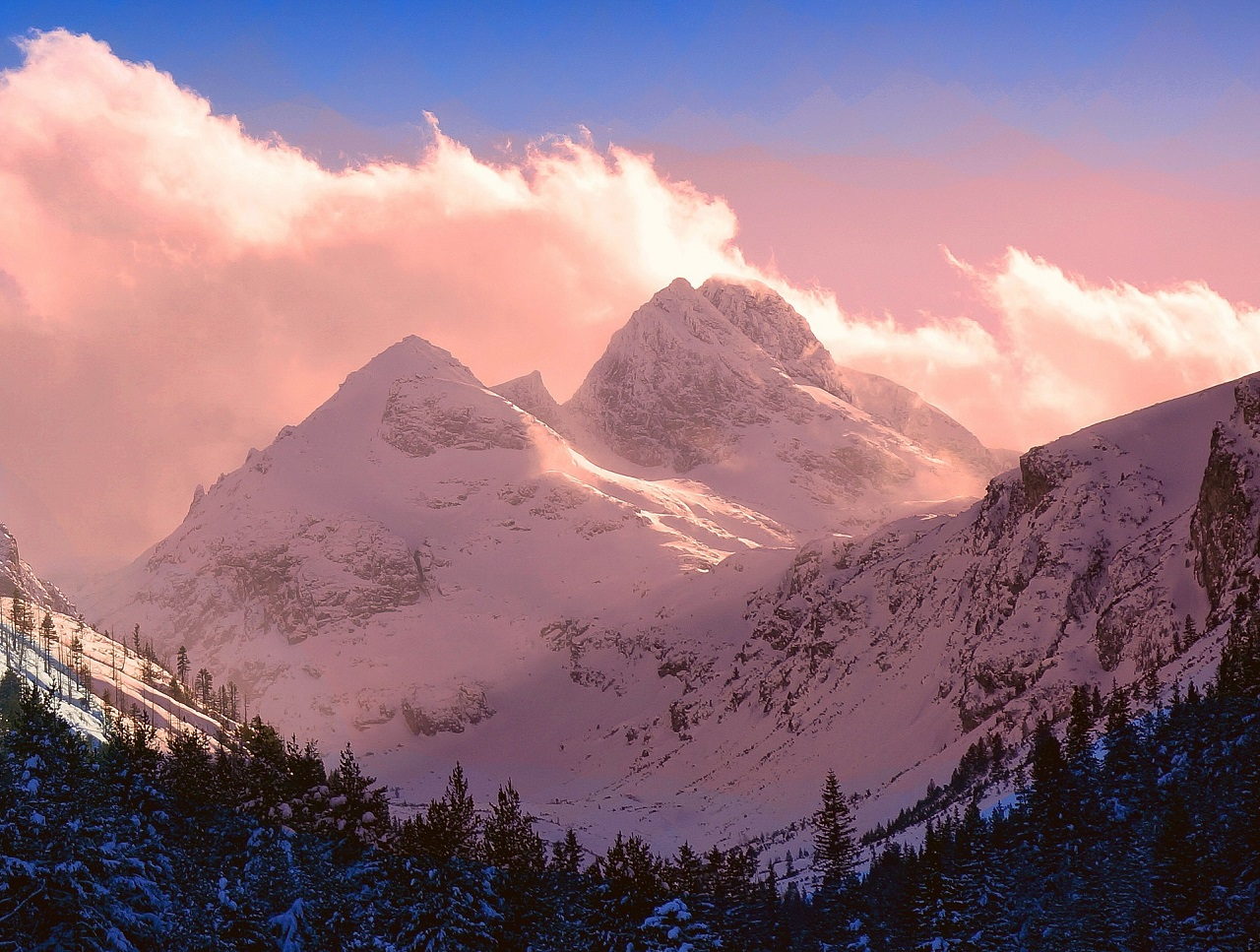
Rila is the highest mountain range in Bulgaria and the Balkan Peninsula, with more than 140 peaks that exceed 2000 meters. With its 2729 meters, Malyovitsa is not among the highest of them, but it’s definitely the most impressive summit in the Rila Mountains, and possibly in the whole country. Its spectacular alpine look and stunning pyramidal shapes are admired by tourists and nature photographers too.
Looking at the above picture, one might think that this peak is only for professional climbers, but not at all. Even though it sounds unbelievable, the summit is easily accessible. While the extremely steep northern slopes are almost impossible to climb, there is a regular hiking trail leading to the top from the southern side. The hike to the summit takes around 3-4 hours, and no special equipment is required, except a generally good level of fitness. And the reward in the end is totally worth the effort.
The picturesque trail starts from the car park of Malyovitsa Central Mountaineering School – which is also the entrance of Rila National Park – and goes past Malyovitsa hut (chalet). About 2.5 km from the hut, the trail reaches the beautiful Deer Lake (Elenino ezero) at an altitude of 2479 m. The western side of the lake gives a magnificent view of Orlovets peak to the east. The hike then continues on a ridge. From there you can even spot Rila Monastery hiding deep down in the valley to the south. Once at the summit, you’ll be presented with gorgeous scenery, including the views of the terraced Malyovishki Lakes and the highest Bulgarian peak, Musala.

Malyovitsa (BG: Мальовица) is located in the northwestern part of the Rila Mountains, the car park itself is 86 km south of Sofia and 13 km southwest of the village of Govedartsi. It is less than 2 hours by car from the capital, so if you’re looking for an easy-to-reach yet challenging day trip from Sofia, Malyovitsa Peak is the perfect destination. The region is a popular hiking location and also the birthplace of Bulgarian climbing and mountaineering. If you wouldn’t like to go all the way to the top, there are numerous other possibilities to hike in the area.
The Wonderful Bridges
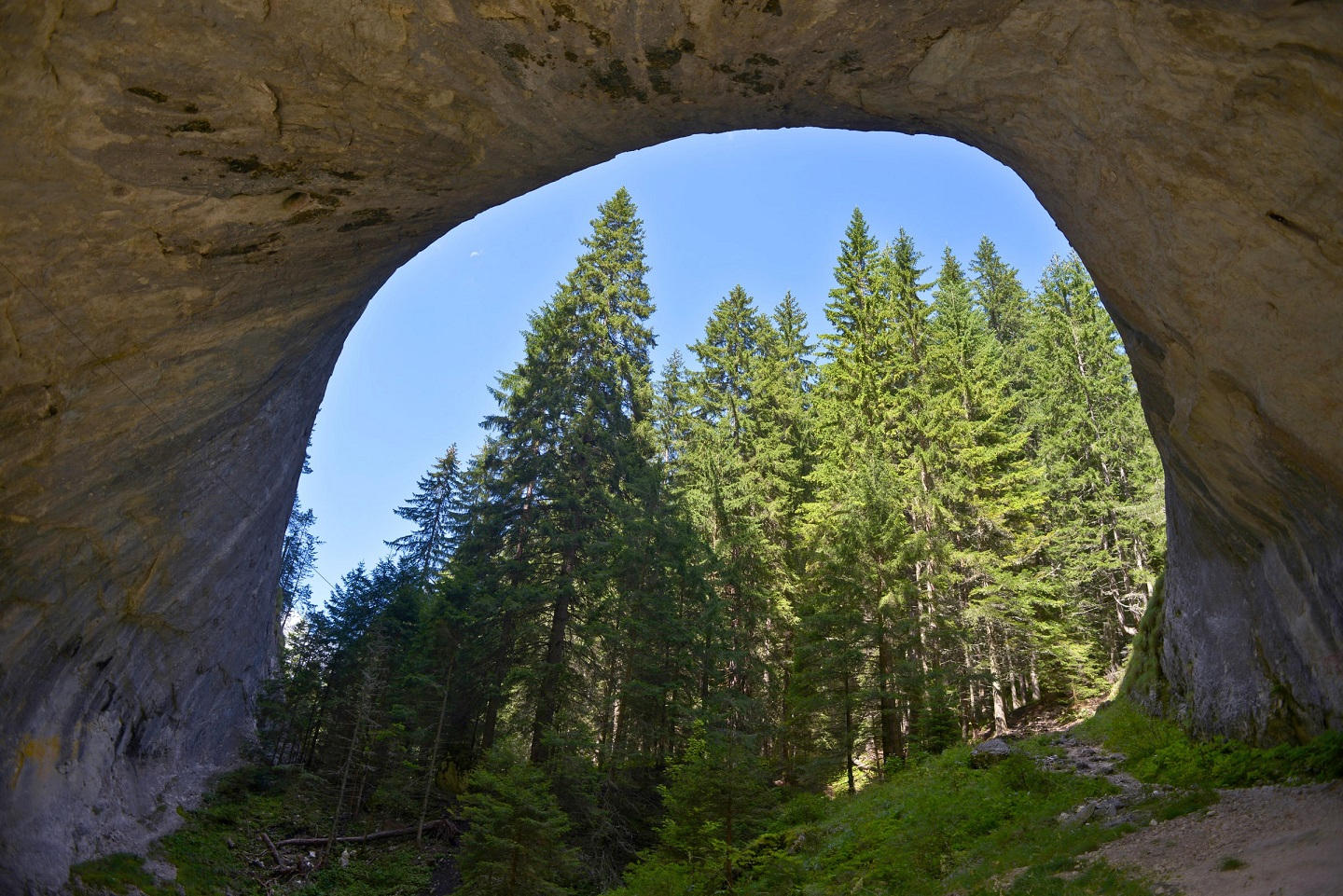
Being officially called wonderful probably makes it easier to rank on this list. The Wonderful (or Marvelous) Bridges are natural rock formations in the Rhodope Mountains, southwest Bulgaria. They mainly consist of two bridge-like marble arches, formed by the erosion of the Erkyupriya River. Once it was a karst cave system that collapsed over time, creating the breathtaking shapes visible today.
The larger bridge, almost 100 m long, has three separate arches, the largest one reaching a height of 45 m. Both Wonderful Bridges can be passed on their top, but the smaller cave, located 200 meters downstream, is not passable under the vaults. However, the hiking trail that goes over it is absolutely worth visiting for the panoramic views. You can also take stunning photos of the longer bridge from there. A bit further down there is a third small bridge, an inaccessible abyssal cave in which the waters of the river disappear and reappear on the surface only after 3 km.
There is a legend about the formation of the Wonderful Bridges that tells about a dragon that appeared out of nowhere many years ago in the village of Zabardo. It started to destroy the herds of local shepherds. One day the villagers found a way to teach the dragon a lesson and punish him for his ruthless behavior. They loaded a donkey with wood branches, set it all on fire and sent the donkey into the forest. The greedy dragon swallowed the burning donkey and eventually collapsed, opening a large hole in the ground. Years later, the dragon’s bones formed the huge rock arches known today as the Wonderful Bridges.
The Wonderful Bridges (BG: Чудните мостове, Chudnite mostove) are located in a karst valley 1450 m above sea level in the Western Rhodopes, 10 km northwest of the village of Zabardo, 30 km from the closest town, Chepelare and 55 km from the beautiful village of Shiroka Laka. The Wonderful Bridges are reachable by car on a narrow road from Zabardo following the well-marked signs. The drive takes around 25 minutes and there is parking available. Near the parking, you’ll find many stalls selling local jam, honey, herbs, spices and souvenirs. There are two chalets there as well offering traditional Bulgarian food. The Wonderful Bridges are a popular tourist attraction, especially in the summer season, so visiting is advised on weekdays.
Tryavna

The romantic, cobblestone streets between the charming houses of Tryavna are ideal for relaxing walks in every season.
This small town, located on the northern slopes of the Balkan Mountains, has been a center of woodcarving, icon painting and other crafts for centuries. In the 1800s, it also became one of the leading cultural hubs of the country, playing an important role in the liberation of Bulgaria as well.
The lovely old town features the only well-preserved square of the Revival period in Bulgaria, Captain Dyado Nikola Square. Surrounded by remarkable buildings, it has a truly unique atmosphere. One of the main attractions and symbols of the town, the clock tower, is located here too, as well as the medieval Church of St. Archangel Michael, showcasing masterpieces of woodcarving in its interior.
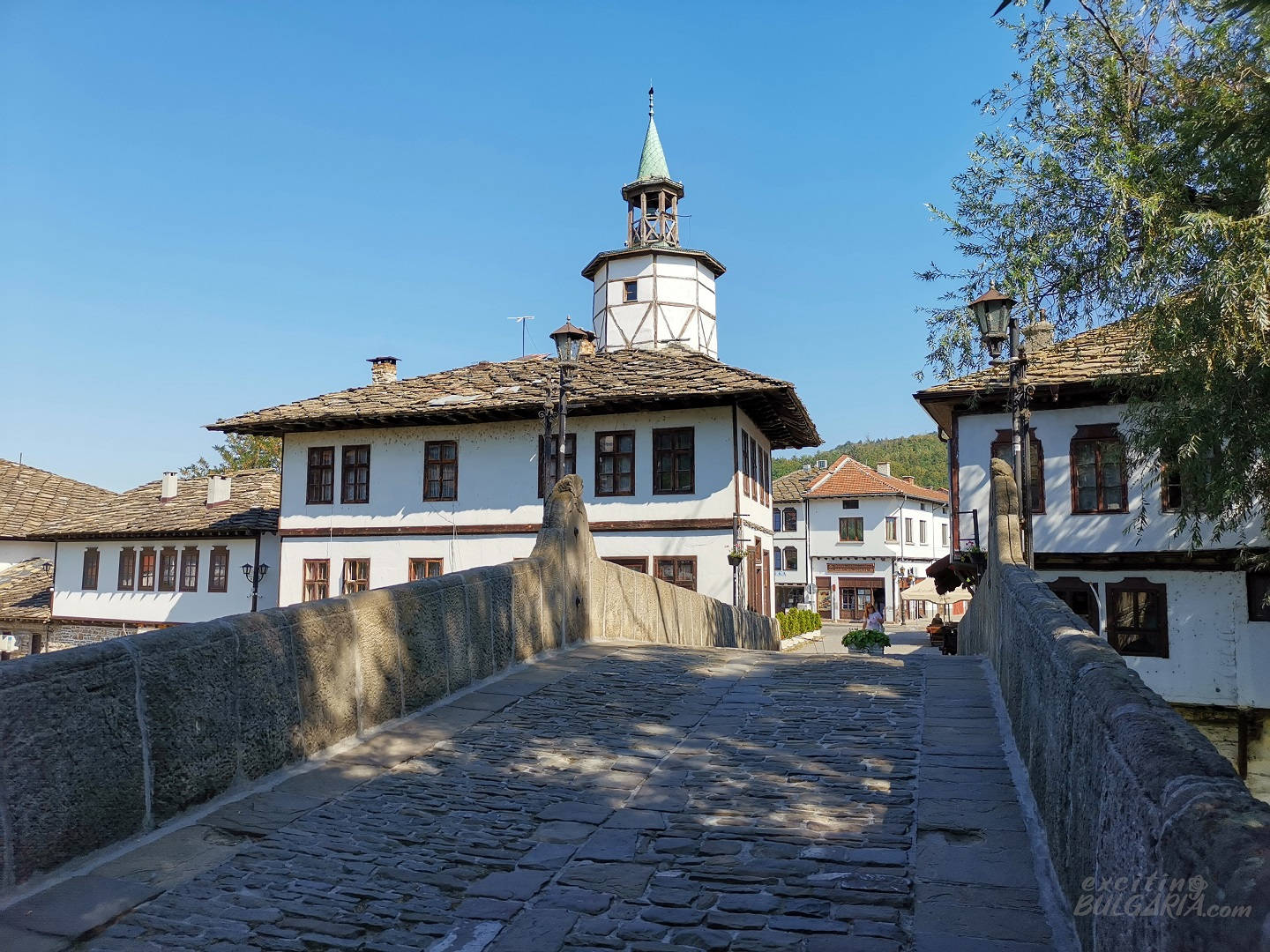
Kivgiren Bridge connects the square with the other bank of the Tryavna river. The 25-m-long stone bridge is another landmark of the town. Continuing across the old bridge takes us to the street of crafts that has various shops offering souvenirs, ceramic and linen products. You can also enjoy a traditionally brewed coffee here: it is made using a heated pan filled with sand.
One of the most impressive houses in Tryavna is Daskalov’s House. Today it accommodates Bulgaria’s only Museum of Woodcarving And Ethnographic Arts, a must-see when you’re visiting the town. Built between 1804 and 1808, the house has a traditional and rich interior design. The most remarkable elements in the interior are the magnificent carved ceilings in the two living rooms, both depicting the sun.

Tryavna (BG: Трявна) is located 22 km east of Gabrovo, 40 km south of Veliko Tarnovo and 225 km east of Sofia. The town has direct railway connections with Veliko Tarnovo, Ruse and Stara Zagora.
Devil’s Bridge
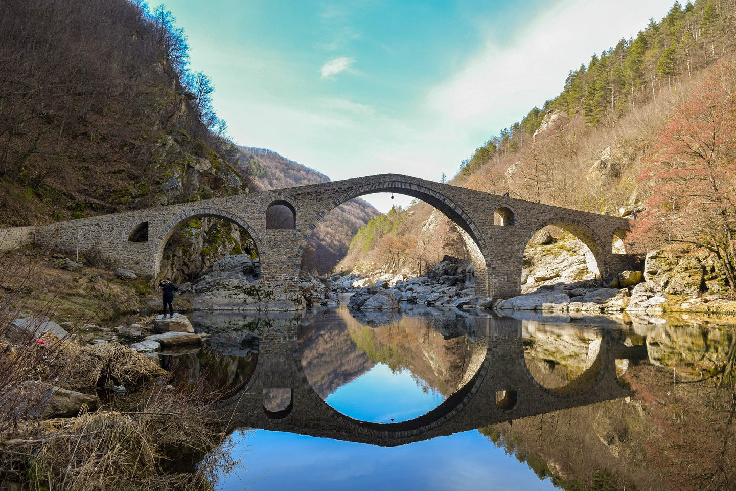
Back to the Rhodopes, here is another bridge with arches again – but this time all manmade.
Built in a picturesque gorge over Arda, the longest Rhodope river, Devil’s Bridge is full of mystical beauty, surrounded by beautiful nature and impressive views. The region has a few similar stone arch bridges, but the Devil’s Bridge overshadows all of them with its massive size: it is 56 m long with the main arch being 11.5 m high.
It is unclear where exactly the bridge got its name, but it has been associated with many legends over the years. According to one of them, between 11 am and noon, when the bridge and its reflection form a circle, the face of the devil can be seen on the waters of Arda. Another story tells about one of the stones showing an imprint of the Devil’s footprint left during one of his walks on the bridge.
Actually, devil’s bridges exist in several places across Europe that are mostly medieval stone bridges. Apart from architectural similarities, these bridges have another thing in common – they all have myths linked with them somehow referring to the devil.
In Roman times, there was another bridge at this place, part of the Via Egnatia road connecting the Aegean Sea with Thrace. It was rebuilt in its current form in the 16th century, more than 500 years ago, and so far no maintenance has been required on it.
Be aware that the Devil’s Bridge is not the destination where you can spend a whole day walking around and taking indeed amazing photos. After having lunch on one of the benches around the bridge, you might be interested in visiting the abandoned village of Dyadovtsi. It is located where the asphalt road turns into gravel, just before reaching the bridge. You can stop by for a little time travel and to take pictures.
Dyadovtsi used to be one of the largest villages in the region, its population was reaching 400, according to local estimates. The major relocations from the village to larger towns and Turkey started in the 1950s, followed by subsequent waves in the next decades. Today, Dyadovtsi is completely depopulated. Don’t get confused, the road between Ardino and Devil’s Bridge passes through a village marked as Dyadovtsi, but that is the new village of the same name.
Devil’s Bridge (BG: Дяволски мост, Dyavolski most) is located in the eastern Rhodope Mountains, 9 km from the town of Ardino, 42 km from Kardzhali and 64 km from Smolyan. The bridge can be reached by an 18-minute drive from Ardino following the brown road signs.
Read more about Devil’s Bridge
Sinemorets
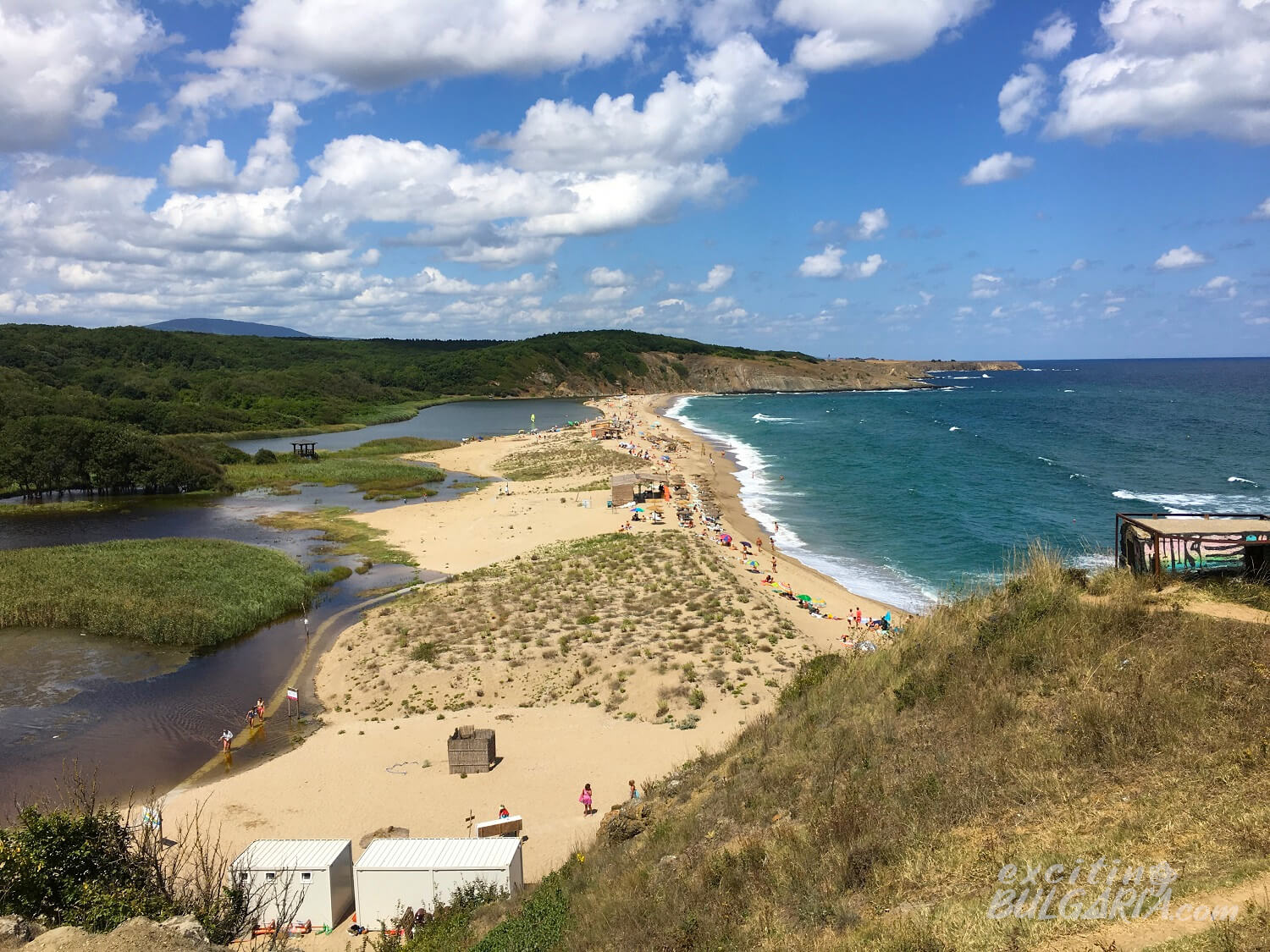
The scenic seaside resort of Sinemorets is located at the mouth of the Veleka River. Before flowing into the Black Sea, the river forms a beautiful lagoon-style beach. It is a one-of-a-kind location where you can swim in the sea and a river only a few meters away, surrounded by pure nature. It is really recommended to visit this unspoiled gem before it gets too popular and overcrowded.
The resort has two lifeguarded beaches with crystal clear water, located on the two opposite sides of Sinemorets. Veleka Beach, the long and narrow sand strip, where you can swim in the sea and the river as per your choice, can be found north of the village. The river has the same fine, sandy bottom as the sea but its water is slightly colder.
The 147-km-long Veleka river has some of the cleanest waters in Bulgaria. It has rich flora and fauna including protected water lilies and 30 different species of freshwater fish. The Veleka originates on the Turkish side of the Strandzha Mountains, reaching a width of 50 m and depths of up to 8 m at its mouth. The river and Sinemorets itself are located within the territory of Strandzha Nature Park, the largest nature park in Bulgaria.
Besides the gorgeous Veleka estuary, Sinemorets has another famous landmark – the so-called Stone Ships. This rock formation, very popular among landscape photographers, consists of two big, sharp rocks emerging from the sea near the coast.
Sinemorets has cozy restaurants, several supermarkets and souvenir shops. It is an excellent location to try the amazing Bulgarian cuisine. However, those looking for a buzzing nightlife should choose a different holiday destination. Sinemorets (BG: Синeморец) is located in Bulgaria’s southeast corner about 15 kilometers from the Turkish border, 80 km south of Burgas.